CONTOURING
| Institution | College |
| Course | DIPLOMA IN LAND SURV... |
| Year | 1st Year |
| Semester | Unknown |
| Posted By | stephen oyake rabilo |
| File Type | |
| Pages | 11 Pages |
| File Size | 483.04 KB |
| Views | 2509 |
| Downloads | 0 |
| Price: |
Buy Now
|
Description
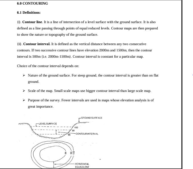
(i). Contour line. It is a line of intersection of a level surface with the ground surface. It is also defined as a line passing through points of equal reduced levels. Contour maps are then prepared to show the nature or topography of the ground surface.
(ii). Contour interval. It is defined as the vertical distance between any two consecutive contours. If two successive contour lines have elevation 2000m and 1500m, then the contour interval is 500m (i.e. 2000m-1500m). Contour interval is constant for a particular map.
Below is the document preview.
Design Highway, Drainage and Hydraulic Structures
Design Highway, Drainage and Hydraulic Structures NOTES .
9 Pages
1353 Views
0 Downloads
1.34 MB
DRAWING INSTRUMENTS AND THEIR USES
DRAWING INSTRUMENTS AND THEIR USES notes for your Diploma in Civil Engineering for your studies.
20 Pages
973 Views
0 Downloads
879.68 KB
AGRICULTURAL EXTENSION AND PLANNING
INTRODUCTION
This module unit aims at imparting the trainee with knowledge and skills that will help him/her understand how rural and urban societies make decisions and receive information about agriculture. It will also provide trainees with programme planning and evaluation skills.
47 Pages
1690 Views
0 Downloads
847.35 KB
COMPUTER PACKAGES COMPREHENSIVE LESSON NOTES
Master essential computer packages with these comprehensive, easy-to-follow lesson notes—perfect for students and self-learners. Clear explanations and practical coverage. Download now and get your instant copy!
125 Pages
1791 Views
0 Downloads
2.34 MB
A DETAILED SAMPLE OF AN ATTACHMENT REPORT IN HEALTH RECORDS AND IT
This is a detailed sample of an attachment report designed in simple language for quick understanding for both the student and the supervisor.it can be used as a sample for any course
10 Pages
965 Views
0 Downloads
477.45 KB
Basic electronics
These notes are well-organized, easy-to-understand, and designed to support effective learning and revision. They contain clear explanations of key concepts, summarized points, practical examples, and neatly structured content to help students grasp topics quickly and confidently. The notes are prepared in a professional format, making them suitable for class learning, personal study, assignments, and exam preparation. Important areas are highlighted to save time during revision and improve understanding of the subject. They are ideal for students looking for simplified yet comprehensive study material that enhances performance and academic success. The content is accurate, relevant, and arranged systematically to ensure a smooth learning experience. Whether you are preparing for continuous assessments, final examinations, or general knowledge improvement, these notes provide reliable guidance and valuable reference material. They are created to make studying easier, more effective, and more productive for every learner.
33 Pages
174 Views
0 Downloads
439.61 KB