Cadastral Survey
| Institution | College |
| Course | DIPLOMA IN LAND |
| Year | 1st Year |
| Semester | Unknown |
| Posted By | stephen oyake rabilo |
| File Type | |
| Pages | 11 Pages |
| File Size | 3.96 MB |
| Views | 450 |
| Downloads | 0 |
| Price: |
Buy Now
|
Description
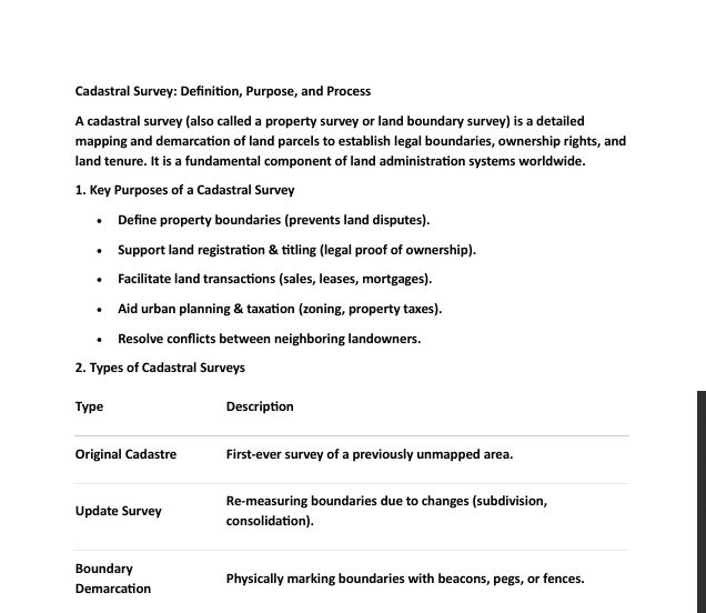
A cadastral survey (also called a property survey or land boundary survey) is a detailed
mapping and demarcation of land parcels to establish legal boundaries, ownership rights, and
land tenure. It is a fundamental component of land administration systems worldwide.
1. Key Purposes of a Cadastral Survey
• Define property boundaries (prevents land disputes).
• Support land registration & titling (legal proof of ownership).
• Facilitate land transactions (sales, leases, mortgages).
• Aid urban planning & taxation (zoning, property taxes).
• Resolve conflicts between neighboring landowners.
Below is the document preview.
Cadastral Survey Past papers
Trending!
Grab copies of past papers on Cadastral Surveying and Land law for your revision purposes.
5 Pages
2570 Views
0 Downloads
998.17 KB
CADASTRAL SURVEYING
Trending!
Grab full notes on CADASTRAL SURVEYING for studies.
88 Pages
2039 Views
0 Downloads
1.5 MB